| Middle Turnpike and Leesburg Turnpike: Remnants of an Early Road |
|
by Debbie Robison February 21, 2015 |
|
There has been a road crossing Difficult Run near the present-day Leesburg Pike bridge for over 275 years. Through the years, the path of the road has altered leaving remnants of these earlier roads still existing today. Although the road is called Leesburg Pike (Rt 7) today, the section of the road from the Alexandria to Difficult Run used to be called Middle Turnpike and the section of road from Difficult Run to Leesburg was called the Leesburg Turnpike. |
| THE MAIN ROAD |
|
The earliest known road along this general route was called the Main Road. It is shown on a plat prepared for William Fairfax in 1739 by surveyor John Warner.[1] The road forded Difficult Run near the present-day crossing of Leesburg Pike. 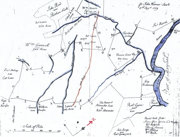
Survey of the Land of
William Fairfax, August 11, 1739, Courtesy Library of Virginia, Colored by
author for clarity, Brown line depicts Main Road. In 1751 the road extended from Alexandria to the west through Vestals Gap.[2] It passed by Minor's Ordinary located in the area of present-day Leesburg. It was down this road in 1754 that George Washington marched in command of the Virginia regiment at the start of the French and Indian War.[3] 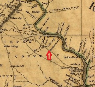
Route of the Main Road
in 1751 Through Vestals Gap, Courtesy Library of Congress Sometime prior to 1771 the route of the main road over Difficult Run was relocated downstream and a bridge constructed. The bridge was mentioned in a Fairfax County court order appointing John Sheppard the surveyor of the road in 1771. The locations of the bridge and the old ford were identified in a lease for land that John Sheppard obtained from Bryan Fairfax. Based on that lease, the location of the road and its features were plotted below. 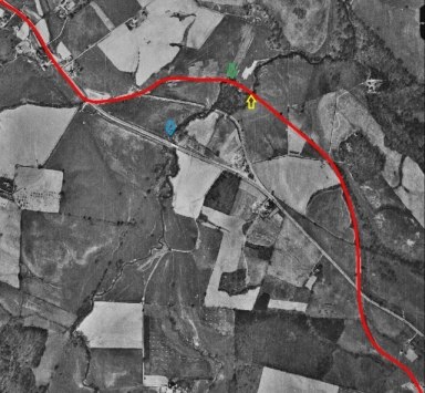
The red line depicts the location of the Main Road by 1771. The yellow arrow identifies the location of the bridge and the blue arrow identifies the location of the old ford near present-day Leesburg Pike.
The bridge was also shown on a plat when the estate of John Shepard was divided.
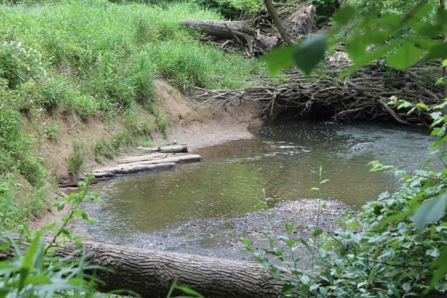
Mid-18th
Century Corduroy Road in Difficult Run, 2013 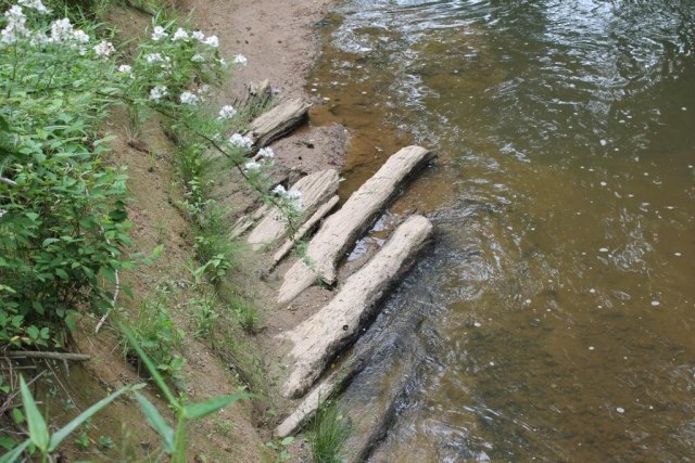
Close Up View of Mid-18th
Century Corduroy Road, 2013 |
| TURNPIKE ERA |
|
Efforts to improve (or maintain) the road were funded by a special annual levy beginning in 1772 and then, when that proved insufficient, by tolls beginning in 1785.[4] The two roads leading from Alexandria to the Blue Ridge through William's Gap and Vestal's Gap (present-day Braddock Road and Leesburg Pike) became “turn-pikes.” [5] The primary motive for improving roads was to facilitate the transportation of produce from the western counties to port towns and to encourage the purchase of commodities that were for sale in the port towns by providing easy return transportation. In consequence of the advantages of having a paved road lead to a particular port town, Georgetown and Alexandria merchants encouraged the construction of turnpike roads to their respective towns. This competition had an effect on turnpike construction in Fairfax County. In 1809 an act was passed by the Virginia General Assembly to incorporate the Leesburg Turnpike Company in order to construct a road from Leesburg to some point on the Little River Turnpike Road.[6] The road would provide the direct access between Alexandria and Leesburg that merchants in Alexandria strongly desired. [7] This was a win for Alexandria merchants; however, merchants in Georgetown also wanted the trade from western Virginia. In December 1812 several petitions were presented to the Virginia General Assembly, signed by inhabitants of Fairfax and Loudoun counties, which would allow the Leesburg Turnpike Company flexibility in deciding the route of the road to Alexandria and to the Falls Bridge across the Potomac River (present-day location of Chain Bridge). The petition also requested that a turnpike company be incorporated to pave a road from a point on the Leesburg Turnpike to the Falls Bridge.[8] As a result, in 1813 the Virginia General Assembly incorporated the Falls Bridge Turnpike Company (present-day Georgetown Pike).[9]The Leesburg Turnpike extended from Leesburg to Drane's Tavern (Dranesville) where it met the Falls Bridge Turnpike.[10] Having turnpikes that were paved from Leesburg through to Georgetown was certainly beneficial for the Georgetown merchants. One proponent of the road stated that Georgetown cannot but feel a lively interest in the promotion of a work which promises to her inhabitants so many important advantages.[11] Unfortunately for others, the Main Road from Alexandria to Drane's Tavern was not paved and travel was difficult. 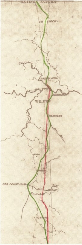
To remedy the drawbacks of traveling to Alexandria, an act was passed in 1818 to establish a turnpike road from Wiley's tavern (on the Main Road about a mile east of Difficult Run) to a point of intersection on the Little River Turnpike Road.[12] The company that was formed to issue stock and manage construction was called the Middle Turnpike Company, probably because it ran between the Falls Bridge Turnpike and the Little River Turnpike. The turnpike somewhat followed the path of the Main Road, but the company made numerous changes in the route to improve travel.[13] Construction got off to a slow start; in fact, the company didn't condemn the land they needed for the road until 1827. In September 1828, Zedekiah Kidwell, Superintendent of the Middle Turnpike Road, advertised for the hiring of laborers, carts, and horses to work on the road.[14] The road was constructed upon the McAdam plan whereby gravel of appropriate sizes was compacted in layers. Gravel for the Middle Turnpike roadbed was obtained from the Cameron Run area.[15] Yet there was a gap in the turnpike road network from Leesburg to Alexandria. At this time, the Middle Turnpike Company was paving a road from the Little River Turnpike to Wiley's Tavern (located about one mile east of Difficult Run) and the Leesburg Turnpike Company was paving a road from Leesburg to Drane's Tavern (located about 4.5 miles west of Difficult Run); hence there wasn't going to be a turnpike road between Wiley's Tavern and Drane's Tavern. The Alexandria Council considered funding the Middle Turnpike extension westward from Wiley's Tavern to Difficult Run but would only do so if the Leesburg Turnpike Company agreed to extend their road eastward to Difficult Run.[16]
In October 1829 the progress of the work was described in the Daily National Advertiser. The whole length of the Road to Difficult Run is about 16 5/8 miles. Of this, there has been levelled and formed about nine miles. Throughout its whole extent, it has been accurately surveyed by an Engineer obtained under an order of the Secretary of War, and minutely re-examined and approved by the Chief Engineer of the Board of Public Works of Virginia. It is reduced to a grade exceeding, in no instance, three degrees, so that all work hereafter done on it will be progressive, and the best road obtained. The distance now formed includes the heavy work at Lucky Branch and the entire extent of Tramel's Hills; in other works, the whole distance from Alexandria to a point somewhat beyond Mateers's Tavern is opened and graduated, with the exception of about two miles; at present delayed by a question with one of the proprietors of the soil through which it passes. With this exception, the right of way throughout the whole distance is acquired. We are happy to say that the work progresses with spirit. It is expected that the Loudoun part of the road will be commenced by the people of that county as a very early day.[17] [Note: James Mateer purchased Wiley's Tavern in 1839, but must have been renting at the time of this newspaper article.][18] In 1830 the Virginia General Assembly passed an act authorizing the Leesburg Turnpike Company to extend their road to some point at or near Wiley's Tavern so that it meets the Middle Turnpike.[19] Nonetheless, due to the high cost, the Leesburg Turnpike Company didn't want to build the bridge across Difficult Run or the elevated causeway through the stream valley. After arbitration, the Leesburg Turnpike Company agreed to extend their turnpike road from Drane's Tavern to Difficult Run and to build 660 feet of the causeway on the western side of the stream.[20] Remnants of the causeway are now part of the Fairfax County Cross County Trail. 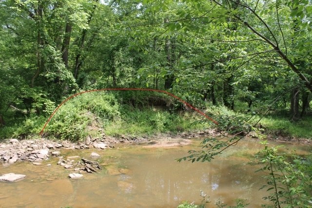
Leesburg Turnpike
Causeway. Sewer pipe construction cut a cross-section through the elevated
road. The Middle Turnpike Company was required to build the bridge, the causeway on the eastern side of Difficult Run, and a road between the bridge and Wiley's Tavern.[21] The route of the turnpike deviated from the path of the Main Road. The crossing over Difficult Run was made upstream of the mid-18th century bridge. 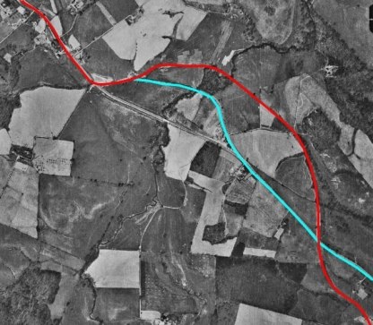
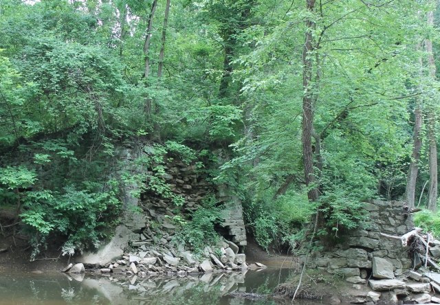
Ruin of Middle
Turnpike Bridge over Difficult Run, Built 1831-1832[24] In 1832 Thomson F. Mason of Alexandria reported on the condition of the Middle Turnpike Company to the Virginia Board of Public Works. At that time, the road wasn't finished yet. The first six miles were well capped with gravel and the seventh only needed a second coat. The remaining portion of the road, with the exception of one mile, had been covered with a 7 1/2″ thick layer of gravel on the McAdam plan. Mason also reported that the bridge over Difficult Run was complete. The company expended $63,056.43 in 1832 but received in tolls only $528.75.[25] In 1833, Mason advertised for proposals for work on the road. PROPOSALS. Will be received by the Presidents and Directors of the Middle Turnpike Company, until 12 o′clock, on Saturday, the 3d day of August next, for breaking the Stone for about one half mile on that road some distance above Wrenn's Tavern. The Stone is already placed on the line of the road. ALSO. For putting on a second coat of screened gravel on about half mile of said Road, above Mrs. Williams'…THOMSON F. MASON, President.[26] Although turnpikes were constructed all the way from Leesburg to Alexandria and from Leesburg to Georgetown, it was the latter market town that got the bulk of the trade. This was caused by a disparity in tolls charged. There were seven toll gates between Leesburg and Alexandria but only four toll gates from Leesburg to Georgetown. In 1837, the Middle Turnpike Company proposed a solution. They requested the Leesburg Turnpike Company move the toll gate they erected on the eastern side of the Difficult Run bridge to a location west of where the Falls Bridge Turnpike intersected with the Leesburg Turnpike. In return for this action, the Middle Turnpike Company agreed to remove one of their toll gates. If this scheme was approved, there would be five toll gates from Leesburg to Georgetown and six toll gates from Leesburg to Alexandria.[27] It is unknown if this scheme was agreed upon by all parties. The Civil War interrupted the collection of tolls and road maintenance.[28] Following government reconstruction, the Middle Turnpike Company turned over the road to the Fairfax County Board of Supervisors in 1872. The debt of the company, in the amount of $300, was funded by the County.[29] The Middle Turnpike, Leesburg Turnpike, and Falls Bridge Turnpike were all abandoned and used as county roads until 1910 when the Virginia General Assembly authorized the incorporation of the Washington and Leesburg Turnpike Company. Initially the turnpike was to extend from Leesburg to present-day Walker Road, then cut over to the old Falls Bridge turnpike and continue to Chain Bridge.[30] The act was amended in 1912 to modify the route. The turnpike extended from Leesburg to Tyson's cross roads.[31] Today you can see remnants of these earlier roads, from the 1830s causeway and bridge ruins to the mid-18th century corduroy road. |
| ENDNOTES |
|
[1] Northern Neck Grant E:103, August 17, 1739, Library of Virginia Grants and Patents [2] A map of the most inhabited part of Virginia containing the whole province of Maryland with part of Pennsylvania, New Jersey and North Carolina. Drawn by Joshua Fry & Peter Jefferson in 1751, Image Courtesy Library of Congress [3] Fairfax Harrison, Landmarks of Old Prince William, Prince William County Historical Commission, Richmond, VA, 1987, p. 482. Reference to Haskett's Orderly Book. [4] Fairfax Harrison, Landmarks of Old Prince William, Prince William County Historical Commission, Richmond, VA, 1987, p. 562. [5] Hands were allotted to work on the turn-pike road from Alexandria to Difficult, July 22, 1788, Fairfax County Court Order Book 1788-92, part 1, p. 5. [6] Acts Passed at a General Assembly of the Commonwealth of Virginia, Samuel Pleasants, Junior, Printer to the Commonwealth, Richmond, 1809, pp. 78-83, as viewed on Google Books. [7] Alexandria Gazette, November 24, 1837, p. 2. [8] Petition for the Leesburg Turnpike to connect with a new turnpike that would extend from the Falls Bridge to some point on the Leesburg Turnpike, December 1812, Legislative Petitions, Library of Virginia. [9] Falls Bridge Turnpike Company Records, 1818-1865, Virginia Board of Public Works, as viewed at http://beta.worldcat.org/archivegrid/collection/data/122538421 on February 17, 2015. [10] Alexandria Gazette, November 24, 1837, p. 2. [11] National Messenger, June 30, 1819, p. 2. [12] “An Act,” Alexandria Gazette, July 27, 1818, p. 1. [13] Richard W. Stephenson, The Cartography of Northern Virginia: Facsimile Reproductions of Maps Dating from 1608-1915, Fairfax County Board of Supervisors, Fairfax, VA, 1981, p.40. [14] Alexandria Gazette, September 22, 1828, p. 3. [15] Alexandria Gazette, August 6, 1830, p. 2. [16] I. P. Thompson, “In Council,” Alexandria Gazette, May 12, 1827, p. 2. [17] “Middle Turnpike Road,” Daily National Intelligencer, October 10, 1829, p. 3. [18] Fairfax County Deed Book E3(57)337, July 27, 1839. [19] Acts Passed at the General Assembly of the Commonwealth of Virginia, Thomas Ritchie, Printer for the Commonwealth, Richmond, 1830, p. 87, as viewed on Google Books. [20] “Middle Turnpike Road,” Alexandria Gazette, November 24, 1837, p. 2. [21] “Middle Turnpike Road,” Alexandria Gazette, November 24, 1837, p. 2. [22] Thomson F. Mason, “Middle Turnpike Company,” Annual Report of the Board of Public Works, Vol. VII, Samuel Shepherd, Printer, Richmond, 1830, p. 343, as viewed on Google Books. [23] Thomson F. Mason, “Middle Turnpike Company,” Annual Report of the Board of Public Works, Thomas Ritchie, Printer, Richmond, 1838, p. 54, as viewed on Google Books. [24] Thomson F. Mason, “Middle Turnpike Company,” Annual Report of the Board of Public Works, Vol. VII, Samuel Shepherd, Printer, Richmond, 1830, p. 343, as viewed on Google Books. [25] Thomson F. Mason, “Middle Turnpike Company,” Annual Report of the Board of Public Works, Vol. VII, Samuel Shepherd, Printer, Richmond, 1835, p. 41, as viewed on Google Books. [26]
Thomson F. Mason, “Proposals,” Daily
National Intelligencer, August 3, 1833, p. 2. [27] “Middle Turnpike Road,” Alexandria Gazette, November 24, 1837, p. 2. [28] Tanya Edwards Beauchamp, Georgetown Pike National Register Nomination, Virginia Department of Historic Resources, 2012. [29] Fairfax Herald, July 11, 1873, p. 1. [30] Acts and Joint Resolutions of the State of Virginia, Davis Bottom, Superintendent of Public Printing, Richmond, 1910, pp. 4-6, as viewed on Google Books. [31] Acts and Joint Resolutions of the State of Virginia, Davis Bottom, Superintendent of Public Printing, Richmond, 1912, pp. 475-477, as viewed on Google Books. Special thanks to those who went out in the woods with me to search for history: To Jim Lewis for sharing his expertise in locating old roads and mill sites, to Jon Vrana for sharing his knowledge in soils and geology, and to Keith Yoder to sharing his GIS skills. |

| Home |
 |
| © Debbie Robison, unless otherwise noted. All rights reserved. |