| Ruins of Silas Hutchison’s Mills Fairfax County, Virginia Built 1851 |
|
by Debbie Robison October 14, 2017 |
| INTRODUCTION |
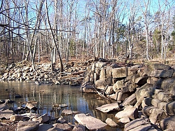
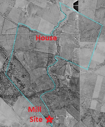
Behind the Westfield High School ball fields in Fairfax County alongside Cub Run are the ruins of the mill dam and other mill features built by Silas Hutchison in 1851.[1] Silas Hutchison’s grist mill and sawmill were constructed on the west side of Cub Run at the southern tip of a parcel of land Hutchison inherited from his wife’s uncle, Joshua Hutchison, in 1842.[2] The Hutchisons were one of the earliest families to live in the area. Andrew Hutchison, grandfather of Joshua Hutchison, settled on a large tract of land in 1726 when he received a land grant for 1,119 acres.[3]
Hutchison’s mill dam
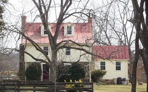
Silas Hutchison lived in a house that was on the farm he and his wife inherited. The house still exists.
Silas Hutchison House, Courtesy Fairfax County Department of Planning and Zoning
|
| MILL CONSTRUCTION |
|
In order to operate the mills, Hutchison needed to construct a dam across Cub Run to create a mill pond to store water needed to turn the mill wheels. But damming the stream would cause flooding on the property on the other side of Cub Run, which Hutchison didn’t own. Because of the importance of grist mills to the farm economy, men who desired to build mill dams could apply to the county court for approval. The property affected by the dam, known as Farmington, was owned by John M Scott. On May 9, 1851 Silas Hutchison wrote a letter to E. H. Henry, Scott’s guardian, advising of his desire to erect a saw and grist mill. Scott had a legal guardian at the time since he was a minor of about 18 years old. Hutchison applied to the Fairfax County Court for a writ of ad quod damnum, which ordered the sheriff to make an inquiry into what damages to Scott’s property would result if Hutchison built the mill.[4] Motion for Silas Hutchison’s Mill Dam, Courtesy Fairfax Circuit Court Archives
Twelve men met on the property in July 1851 with the deputy sheriff to determine the amount of compensation due Scott. The men agreed that the dam, to be 7’ high measured from the bed of the stream, would not take more than one acre of Scott’s land. Scott was awarded $10 in compensation for the land used to build the dam and $20 for the land that would be overflowed with water. It was noted that that dam would not obstruct ordinary navigation or the passage of fish, and that no damages would be awarded due to construction of a canal since the canal was exclusively on Hutchison’s property.[5]
Silas Hutchison Farm, USDA Aerial image, 1937, Courtesy Fairfax County
|
| MILL HISTORY |
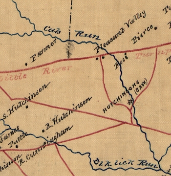
Not much is known about the operation of the mill, though Civil War maps indicate that the Hutchison mill was operated as a saw mill in 1863. Joshua M. Hutchison, Silas Hutchison’s son, may have worked at the saw and grist mill. In the 1860 federal census, Joshua Hutchison’s occupation is listed as laborer, while the occupation of his brother Charles is listed as a farm hand.[6] Joshua Hutchison likely inherited the saw and grist mill upon his father’s death about 1883.[7] Silas Hutchison’s personal property was sold in an estate sale in January 1884. Some of the items may have been associated with this mill, including mill stones and a grind stone. In addition, a two-horse lumber wagon was purchased by Joshua Hutchison.[8] It is unknown if Joshua Hutchison continued to operate the mill once he inherited. In 1887 when he advertised a farm for sale he noted that there was a saw and grist mill convenient to the property. However, he may not necessarily have been referring to his saw and grist mill on Cub Run.[9] Map of Fauquier & Loudon [sic] co’s. Va. by order of Lt. Col. Wm. P. Smith Chf. Eng’r. Topol., 1863, Courtesy Library of Congress, Geography and Map Division |
| USE OF THE MILL DAM IN THE 20TH CENTURY |
|
Although there is no known evidence that the mill continued in operation from the late-19th century onward, the mill dam was maintained. Mortar containing a Portland cement binder was used to construct a portion of the dam and again later for maintenance. Portland cement was not widely used in this country until the 1880s. 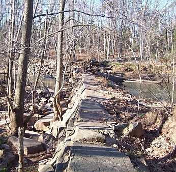
One possible explanation for the continued maintenance of the dam is that it may have served as a bridge across Cub Run. An old dirt road leads to the area around the mill ruin and directly to the dam. For 25 years, the Adams family possessed the land on both sides of the mill dam. Then the Butkiewicz family owned the property on both sides of the dam for 28 years until the land was sold to developers in 1972.[10] The Fairfax County School Board acquired the property in 1994.[11]
Top of Hutchison’s mill dam |
| DESCRIPTION OF THE MILL SITE |
|
Water-powered grist mills operated seasonally after periods of harvest. Since a major milling period was in August when the flow of water is low, millers constructed mill ponds to provide a reliable source of water to power the mill. 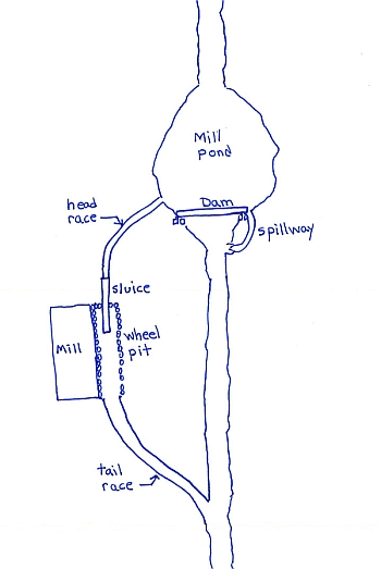
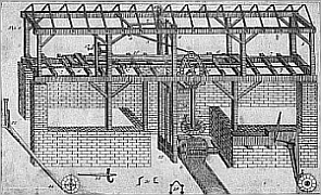
Water was conveyed from the pond through a head race to the mill’s wheel where it caused a percussion force to turn the wheel. A tail race directed water back to Cub Run. In periods of high water, a spillway on the far side of the dam provided relief so the water in the pond wouldn’t flood the mill site. The head race, which has deteriorated due to erosion, begins at the top of the mill pond and continues to the mill ruin. Most mills in Fairfax County were overshot mills whereby the water was conveyed through a wooden sluice to the top of the wheel; however, there doesn't appear to be sufficient height at the Hutchison Mill to raise the water to the top of the wheel. Perhaps this mill had an undershot wheel or perhaps this ruin was the sawmills. Stones on both sides of the channel near the mill ruin suggest that there may have been a wheel pit. The tail race, which is in good condition, extends from the mill ruin along the run for about one hundred yards to where the water discharges back into Cub Run. The tail race continues to collect stormwater, which is channeled to the run.
Layout of Silas Hutchison’s Mill Site
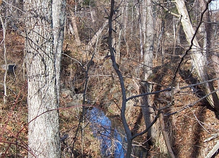
Mill tail race
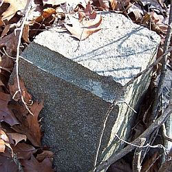
The large dam, which extends across Cub Run, is constructed of dressed stone (shaped by a stone mason), likely quarried nearby. This stone shows where a mason drilled when quarrying.
Quarried stone at site
The dam is approximately 200’ long across Cub Run and about 7’ tall. The dam continues for approximately 40 additional feet on the western side of Cub Run and terminates at what may have been a water gate within the head race. The cross-section of the dam is trapezoidal in shape, though sediment has deposited on the upstream side of the dam. The base of the dam is approximately 8’ wide, while the top of the dam is approximately 2’ wide. The top of the dam is sloped, allowing water to be conveyed off the top of the dam. The easternmost portion of the dam is set with mortar containing Portland cement; however, there is no evidence of mortar on the westernmost portion of the dam. Two different mortar applications are evident. The first application of mortar contains small aggregate and a later mortar containing large aggregate. A small section of the dam was removed to allow for the flow of stormwater. Hutchison’s mill dam
Cub Run flows in a southerly direction, hence the mill pond was north of the dam. The area of the mill pond is clearly evident due to the type of vegetation and the well-defined embankments. Ponding continues to occur in this area during major storm events. Hutchison mill dam with pond area beyond A portion of the stone foundation of the mill, probably the wheel pit, remains on the western side of Cub Run and a corner of the structure is evident. 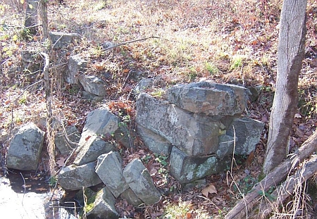
Portion of mill foundation Older portion of Hutchison's mill dam |
| ENDNOTES |
|
[1] Fairfax County Minute Book 1846- , 16 June, 1851, p. 332. [2] Fairfax County Will Book U1(670):38. 17 Oct 1842, Joshua Hutchison’s will. [3] Northern Neck Grant Book A:224, 18 Aug 1726. [4] Fairfax County Minute Book 1846- , 16 June, 1851, p. 332. [5] Fairfax County Circuit Court Term Papers, June 1851, Box 2, Silas Hutchison Motion for a mill affecting John Scott; Also, 1870 Federal Census indicates that Scott would have been about 18 years old in 1851. [6] Federal Census of 1860. [7] Fairfax County Will Book E2(680):123; Estate sale notes that Joshua Hutchison was a legatee of Silas Hutchison. [8] Fairfax County Will Book E2(680):123, 15 January 1884. [9] Fairfax Herald, 22 July 1887, p. 2. [10] Fairfax County Deed Book 3609:519, 28 April 1972. [11] Fairfax County Deed Book 9037:949, 15 March 1994. |

| Home |
 |
